Thanks to Peter for finding this document.
"whilst having a look on the Chester Archaeological Societies web page saw
there's a new standard out for pottery excavation. Heavy reading, but
may be worth having a read"
Click on this link to open the document 'Standards for Pottery Studies in Archaeology'
Wednesday, 12 October 2016

Tuesday, 11 October 2016
Zoomorphic jug spout
This, for me, was the star find of the summer. A nearly complete zoomorphic jug spout, just one horn missing, so watch out for it as it came from the context 43 section. It will be easy to spot, as it has a grove cut into it.

Click on the link below to see a 3D model I created of this which you can move around with your mouse!
https://sketchfab.com/models/83b35ede5e2f46ecadcc8aad6e408a14

Click on the link below to see a 3D model I created of this which you can move around with your mouse!
https://sketchfab.com/models/83b35ede5e2f46ecadcc8aad6e408a14
Lidar image for Ashton
Quickly produced this lidar image for Ashton, where a similar kiln was found.
Sadly, on 2m data available for this area, but by exaggerating the vertical height and putting the sun to the South it looks a decent analysis
C

Sadly, on 2m data available for this area, but by exaggerating the vertical height and putting the sun to the South it looks a decent analysis
C
Monday, 10 October 2016
Possible Roman roads around Brereton Park, Huxley
4th March 2015
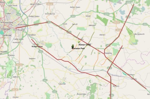 Another day, another free package from Microsoft.
This one is called Sway and is for web presentations.
I have tested it will material I have worked on in my lunch hours (it's cold in Bolton) on Roman roads in our area. Enjoy.
Click on the link to see the full presentation of Roman roads around Brereton Park, Huxley
https://sway.com/COsP3X080ER5Djx_
C
Another day, another free package from Microsoft.This one is called Sway and is for web presentations.
I have tested it will material I have worked on in my lunch hours (it's cold in Bolton) on Roman roads in our area. Enjoy.
Click on the link to see the full presentation of Roman roads around Brereton Park, Huxley
https://sway.com/COsP3X080ER5Djx_
C
Sunday, 9 October 2016
Saxon kiln
Hi all, this is the photo
of the complete pottery kiln I mentioned last Saturday.
It is a foot taller than ours and you can clearly see the marks from the wattle and daub dome. Although earlier it gives you a good idea of what kiln1 could have looked like.

It is a foot taller than ours and you can clearly see the marks from the wattle and daub dome. Although earlier it gives you a good idea of what kiln1 could have looked like.

Finally get to see the bottom of the kiln wall
Just a quick update on last Saturday (1/10/2016) where we finally got our first sight of the bottom of the kiln.
Thanks to the help of our architect, we managed to work undercover in the rain.

We reached the side of the kiln last week by
removing the red pottery/kiln material layer (context 52), with context
53 (dark grey clay with charcoal) touching the side of the kiln.
Interesting to note all the charcoal/burning as if this surface was
exposed during the firing of the kiln. The layer above this (52)
'peeled off' as if it had been a flat surface.

So this week a small, and I mean small, section
was cut into context 53 to expose context 54, which we suspect is the
underlaying natural clay to expose the bottom edge of the kiln wall.

So the sequence of events in the current ‘theory’ would be:
- The
natural clay (Context 54) was leveled in preparation for the building
of the kiln. There is still the possibility that a pit could have been
dug, and the kiln built into that, time will tell.
- I
only had a peek, but it is possible that there is a thin layer of
crushed kiln material at the base (or it may just have been a different
colour as it had just been exposed).
- The
kiln was built up, and when fired, hardened the natural clay (Context
54) underneath. Context 54 was firm next to the kiln, but not fired.
- During the firing of the kiln a grey clay layer 2cm deep built
up with black flecks of charcoal or burning evident. This could have
just been muddy conditions with charcoal settling onto it. No pot has
been found in this layer.
- At
some point, a wedge of kiln wall material and pot sherds (Context 52)
built up against the side of the kiln. This is creating the slope that
we see in later layers and stops about 1m from the kiln.
- After the kiln went out of use, a dark layer filled with pot
sherds (Context 43) was laid over the kiln and at least 2m to 3m around
it on the south side. This could have come from the cutting of the
boundary ditch, but the vast quantity of material in this layer offers
up the possibility that it was part of the decommissioning of the kiln
when it went out of use with the site being leveled. The black could be
a soil layer that built up between the pot sherds between the kiln
going out of use and the cutting of the ditch.
- The white clay (Context 12) and the red clay (Context 8) layers were created when the ditch was cut.
The
simple sequence above suggests to me that the kiln may have only been
fired for one season, to service a single contract (eg. The building of a
single castle). Maybe there are kilns that are in regular use for local
demand, and then every few years they get a big ‘sale’ and have to up
production for a short period by creating an extra kiln.
I have a 3D model of the section to play with so we can profile exactly the shape of the kiln wall.

Video review of summer 2016
Hi all,
thought it would be a good idea to do a short video of what we have been up to this summer.
It is on YouTube but hidden from search so you can only get to it from the link below.
thought it would be a good idea to do a short video of what we have been up to this summer.
It is on YouTube but hidden from search so you can only get to it from the link below.
Subscribe to:
Posts (Atom)